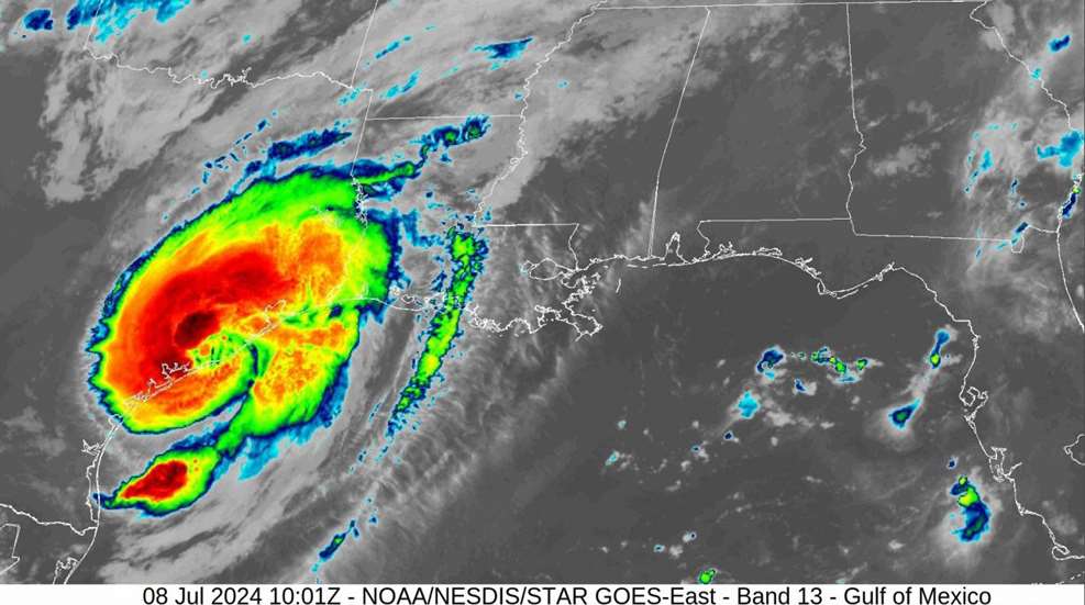
If July 2024 was an indicator of what hurricane season would be like throughout that year, the Gulf Coast states, and many others, were in for a long summer. Hurricane Beryl came ashore around 4 a.m. on July 8 as a Category 1 storm, making landfall near Matagorda, Texas, in between Corpus Christi and Galveston. Maximum sustained winds of 80 miles per hour lasted for hours. Hurricane Beryl retained strength and continued slamming the coastal communities as she sluggishly moved northeast, approaching the Greater Houston area. After 6+ hours of sustained hurricane-force winds, Beryl finally weakened a bit to tropical storm status, only after leisurely passing through the city, across the suburbs, and leaving a path of destruction that was not supposed to happen with “just a Category 1 Hurricane.”

Don’t fall into the mindset of a storm being “just a _____ storm.” You will be caught off-guard when a storm does not do what it is “supposed” to do within the boundaries of the category it is placed within.
Hurricanes spin counterclockwise. If you live “below” or to the west/south of where the hurricane is projected to make landfall, you are said to be on the “clean” side of the storm and will rarely experience rains, winds, or damage. On the other hand, if you live “above” or to the east/north of where the hurricane is projected to make landfall, you are said to be on the “dirty” side of the storm. Here is where you will experience the lashing of winds and rain bands as the storm continues to spin counterclockwise and “train” its effects over your location.
Most tropical storms and hurricanes lose their fury and strength when they move over land, breaking apart and disorganizing pretty quickly. Beryl, on the other hand, continued as a tropical depression moving across East Texas, Louisiana, Arkansas, Missouri, Illinois, Indiana and Michigan, and finally fading away once reaching Canada on July 11. Beryl showed millions of people how “just a … [disturbance, tropical storm, and Category 1 hurricane] wreaked havoc over her 14-day lifespan.
All too often we become complacent with events that we may experience in our daily routines, weekly, monthly, or annually. We have a standard in our mind what the event will be like before, during, and after. We also have an idea of how we are going to prepare, react or respond to said event. Anyone living in the South, especially along the Atlantic or Gulf Coast regions knows the significance of June 1 through November 30 each year: Hurricane Season.
According to the Saffir-Simpson Hurricane Wind Scale, which is a rating based on a storm’s sustained (1-minute average) wind speeds and estimation of potential property damage, there are different categories of storms.
Tropical depression: A tropical cyclone with winds that are 38 mph or less.
Tropical storm: A cyclone with wind speeds between 39-74 mph.
Hurricane: A cyclone with wind speeds higher than 74 mph.
Category 1 Hurricane: Winds 74-95 mph; dangerous winds can damage roofs and structures; large branches of trees can break, and trees may fall; power lines and poles are affected and will probably result in power outages.
Category 2 Hurricane: Winds 96-110 mph; extremely dangerous winds causing extensive damage; well-constructed buildings could sustain major damage; trees will snap or uproot and can fall across roads; power loss is expected.
Category 3 Hurricane: Winds 111-129 mph; devastating damage will occur; well-built structures may suffer major damage; trees will fall; electricity and water will most likely be unavailable for several days to weeks post-storm.
Category 4 Hurricane: Winds 130-156 mph; catastrophic damage will occur; well-built structures will experience severe damage with loss of roofs and exterior walls; trees and power poles will be down, usually isolating residential areas; power outages may last weeks to possibly months.
Category Five Hurricane: Winds 157 mph or higher; catastrophic damage will occur; homes and structures will be destroyed; trees and power poles will be down and isolate residential areas; power outages will last for weeks to possibly months; most of the area will be uninhabitable for weeks or months.
Before a Storm
There are many things you can do to prepare yourself long before hurricane season approaches. Knowing the minimum requirements to survive, and what YOUR minimum requirements are to stay comfortable, will help in preparedness. Clear an area in your closet or storage area to designate as your “emergency supply stash.” Each month, add a few items to your shopping list to have available in case of a storm emergency. Estimate 1 gallon of water per person, per day, and have enough water to last at least a week. If storage space is limited, consider purchasing water purification tablets or a “life straw” filtration device in case water is not safe to drink after a storm. Regularly stock up on non-perishable food items such as canned goods, rice, pasta, and protein-packed nutrition. Make sure you also stock up on extra food and treats for your pets. Always keep an emergency amount of cash available, whatever you can afford, in anticipation of credit card services, ATMs, and electronic payments not being available when a disaster occurs. Try to plan and have enough over-the-counter and prescription medicine available if you can.

We have all become accustomed to relying upon our technology, especially our phones, for quick access to a flashlight and our favorite apps that stream the news, music, and weather. When our smartphones and tablets run out of juice, it is best to have several backup devices to stay safe. Have at least one battery-operated radio and a NOAA weather radio to stay current with the latest news and storm radar. Have several flashlights available of different sizes and abilities for convenience, and extra batteries to keep everything running.

A Storm is Coming
Fortunately, because tropical lows, disturbances and developing storms usually take some time to build in strength and organize as they move across open waters, meteorologists usually have a good indication of when areas will be affected. People usually have at least a few days to make their final preparations if they are in the direct path of a storm. Regardless of the strength of a storm and projected area of landfall, it is best to assume the path of it will change, veer, and become erratic, presuming everyone in the surrounding radius or “cone of uncertainty” may be affected in some way.
The priority is to fuel up all of your vehicles and additional gas cans, if needed. When power goes out, so are gas and diesel pumps. Charge up all phones, tablets, laptops, and any other device that can run off battery power for a while. Stock up on portable chargers and keep them at full power. Double-check your “emergency supply stash” and make sure all items are readily accessible and ready to use. Don’t overlook your pets; make sure they will be taken care of during an emergency. If you have Storm/Hurricane Shutters that are powered by a switch, do not lower the shutter to the ground if covering a door, for safety. If you lose power the only way out is to use the manual hand crank, which can be stressful if you need to get out quickly.
During a Storm
If you are planning to “ride out” a storm and shelter in your home, remain inside and away from windows to protect yourself from flying debris, limbs, or other projectiles that tend to do supernatural things during a storm. If you happen to be in the path of a hurricane, the storm can unleash its fury for several hours as it passes over your location, lashing and pounding its way along its track. When the storm calms, do not let your guard down just yet…you’re only halfway through.
Next to come is the eye of the hurricane. This is the center of the storm. The eye is produced by intense rotation, which causes air to sink and creates a calm and eerie atmosphere. The winds are light to non-existent. If it’s daytime, the sky is clear, and the sun is bright. If it’s nighttime, the sky is clear, and stars span for miles. The eye is surrounded by the eye wall, which is generally a tight area containing the most intense winds and heaviest rainfall, and the most dangerous conditions where destructive weather occurs.
As the eye moves across, the storm's winds change direction as conditions rapidly deteriorate. Debris that may have been shifted or displaced during the onset of the hurricane winds can now become dangerous as the second round of storms and winds pass over the same area. Heavy rains and the potential of flash flooding are possible as rain bands relentlessly swirl around the eye wall of the storm. Stay indoors until the storm has passed, winds have subsided, and thunderstorms have ended.
After a Storm
Only when it is safe to do so, carefully go outside to assess any debris on your property, destruction in and around your structures and vehicles, or property damage post-storm. Take a lot of photos of any damage that occurred and document details of any issues. Check on your neighbors to see if they are ok and if they need immediate assistance after the storm. When starting the clean-up, wear sturdy gloves (leather) to protect hands from nails or other sharp edges that may now be exposed in the aftermath.
Reach out to local authorities for updates on heavy trash pickup, how to stack debris, limbs, etc., and other instructions for services. Contact FEMA to apply for assistance if you experience a power loss that resulted in spoiled food that was ruined in your freezer. Contact your community association and local authorities, and stay informed if there will be distribution sites to offer cases of water, food, and other resources needed post-storm. Reach out to the American Red Cross, local churches, and food pantries if you need food or other necessities as you recover from the disaster.
Houston and surrounding areas suffered widespread wind-related damage. More than 2.2 million people suffered power outages. This was significant considering the Greater Houston area has a population of over 4 million. Many residents were without power for anywhere from two to 10 days, and some were left in the dark even longer. Since Beryl made her appearance in early July, temperatures in the South were already on the rise. Several people were caught off-guard by Hurricane Beryl. First, because it came so early in the season. Next, because it was “just a Category 1” storm. Hurricane season runs through the end of November. There is still time to gather supplies for additional potential storms and be prepared for the worst while hoping for the best.